Kili 01- Route Notes
Excerpts from
Kilimanjaro & Mount Kenya - A
Climbing and Trekking Guide
by M. Burns
Map of routes
The Route
While the Marangu Route is dubbed the Coca-Cola Route, the
Machame Route is known as the Whiskey Route. It's more expensive to ascend,
and its fantastic views are much more intoxicating.
Like other forest routes on this side of Killi, the Machame Route
is generally considered an ascent route. When combined with the Barafu
Route on Kibo to the summit and the Mweka Route as a descent through the
forest (also known as the Machame-Mweka Route), it is easily the best forest/moorland
route for acclimatization on Kilimanjaro, as well as one of the most scenic
outings on the mountain.
It climbs slowly through the forest before emerging on the edge
of the Shira Plateau and joining the Shira Plateau Route, then traverses
the mountain, taking in the South Circuit Path, with overnight stops at
Barranco Hut and Barafu Huts before a slow grind up Kibo to the sum- mit.
Because of the slow ascent, this combination route has the highest rate
of success of any route on the mountain.
The Machame Route, by itself, is also
the second most beautiful route on the mountain after the Umbwe Route.
It starts above the village of Machame, on the southwestern slopes of Kilimanjaro.
Like most villages in Africa, Machame has no real center but is strung
along the road for several kilometers. To reach the village, drive west
on the Arusha-Moshi Road from Moshi for 13 kilometers, then turn right
onto the Machame Road (signed) and drive another about 7 kilometers. When
you reach the village market, veer left between the buildings. Another
few kilometers of steep dirt road will lead to the well-marked Machame
Gate.
MACHAME ROUTE: MACHAME GATE TO MACHAME HUTS / DAY l
Ascent: 1,800 meters to 3,000 meters
Distance: 10 kilometers
Time. 5 to 6 hours
The trail bypasses the park offices to the left (west), then follows
a four- wheeLdrive road for several kilometers before it begins thinning
to a narrow jungle track that follows a ridge. The trail is well used,
so losing it is not an issue. Five to 6 hours of hiking brings you to Machame
Huts, at 3,000 meters. Like nearly all the huts on Kill--except those on
the Marangu Route--they are Uniports in a state of disrepair. There are
good camping sites on the hillside above the huts (to the east), and fresh
water is available from the creek down the steep hill behind the huts to
the northwest.
MACHAME ROUTE: MACHAME HUTS TO SHIRA HUT / DAY 2
Ascent: 3,000 meters to 3,800 meters
Distance: 7 kilometers
Time: 5 hours
From Machame Huts, the trail enters the moorlands and more
or less follows a fin of volcanic rock protruding from the mountain. About
2 hours from Machame Huts, the trail reaches a semicircular rock wall that
must be negotiated. The wall is a scramble (American Class 3), but it is
short (8 meters), and exposure is not a problem. The average per- son with
no climbing experience whatsoever--can manage it. Above the wall is a scenic
rest stop.
Next, the trail heads northwest, away from Kibo,
and crosses two streams before emerging on the $hira Plateau, near Shira
Cave. Shira Hut lies a few hundred meters to the northwest. Most parties
camp near the cave, as Shira Hut is old and dirty.
At this point, the Machame Route has joined the Shira Plateau Route.
Shira Plateau Route, below.)
SHIRA PLATEAU ROUTE
To reach the trailhead for the Shira Plateau Route, drive west from
Moshi [i on the Arusha-Moshi Road for 26 kilometers, then turn right (north)
~for 22 kilometers to the town of Sanya Juu. Often your guide will stop
in Sanya Juu for last-minute supplies or lunch. From Sanya Juu, it's another
40 kilometers or so to Londorossi, and the roads get progressively worse.
To the first-time visitor, LondorossI looks like a town straight out of
a Hollywood Western. It is constructed entirely of wood, and its
dirt streets conjure up images of Tombstone. It's easy to go the wrong
way in Londorossi, but watch for signs pointing to the Londorossi Gate.
It's possible to drive the 11 kilometers from the gate all the way to
the trailhead at 3,500 meters; however, the road is extremely rough.
(There are no facilities at the trailhead except an outhouse-style toilet.)
SHIRA PLATEAU ROUTE: SHIRR PLATEAU ROUTE TRAILHEAD TO
SHIRA HUT / DAY 1
Ascent: 3,500 meters to 3,800
meters
Distance: 6 kilometers
Time: 4 hours
From the trailhead, the trai! goes east, breaking out across the center
of the Shira Plateau. About 3 to 4 hours' walk from the trailhead, you
will reach Shira Hut. There are many campsites within the first few kilome-
ters along the Shira Plateau Route, and a late start from Moshi often necessitates
camping before reaching Shira Hut.
Shira Cave lies another 20 minutes' walk to the south-southeast of
Shira Hut. Most parties camp here rather than at Shira Hut, which is old
and dirty. There is camping near the cave (about 5 minutes' walk to the
westssouthwest of the cave), where a second large cave often serves as
a kitchen/campsite for porters and guides. There is a tremendous pile of
garbage at this camp, and at night, dozens of dik-dik roam about, picking
at the mess. Camping in the Shira Cave is prohibited. There is a wooden
toilet building next to it.
Water is available from several sources. If you've come up the
Machame Route, there are two creeks back along the Machame Route, toward
Machame Huts. The first stream is about a 10-minute walk from Shira Cave.
A closer water source is a creek about 300 meters direcdy west of Shira
Cave. Sometimes, however, this creek dries out.
From Shira Hut, it is possible to go in several different directions:
to Lava Tower Hut, to Moir Hut, or to Bartanco Hut. That's because just
east of Shira Hut, the Shira Plateau trail meets the North Circuit Path,
which gives numerous options.
Because most dimbets who use the Shim Plateau trail (or portions of
it) are either headed for the Western Breach Route on Kibo or doing the
Machame-Mweka combination route, those two sections of trail are covered
below.
SHIRA PLATEAU ROUTE: SHIRA HUT TO ARROW GLACIER HUT / DAY 2 OPTION
l
Ascent: 3,800 meters to 4,800 meters
Distance: 6 kilometers
Time: 3 to 4 hours
From the Shira Cave area, the Shira Plateau trail skirts right (south)
of the cave and then follows a long, low, thin fin of rock for several
kilome- ters before it slowly trends southeast, aiming for a striking tower
of rock, Lava Tower. About halfway between Shira Cave and Lava Tower, the
North and South Circuit Paths join the Shira Plateau trail. The junc- tion
is not well marked. In fact, the only indication that you have inter- sected
the North and South Circuit Paths is some red spray paint on a rock stating
"Moya Hut" (Moir Hut).
At this point, you can follow the North Circuit Path left (north) to
Muir Hut or the South Circuit Path right (south) to Barranco Hut, or you
can go straight, which takes you toward Lava Tower Hut and the trail up
to Arrow Glacier Hut. After intersecting with the
North and South Circuit Paths, the Shira Plateau trail flattens out a little
bit and continues east4outheast to Lava Tower.
Just after the intersection, the trail crosses a
fairly deep valley, and climbing out of it is a grind. Above this hill,
the path crosses two broad, flat valleys before reaching Lava Tower Hut
(4,500 meters). The hut is a ruin, and the area is rarely used for camping.
Lava Tower Hut is the ~ po'mt for the Western Breach area (also known
as the Arrow Glacier area) and the Western Breach Route. Just east of Lava
Tower, the small trail to Arrow Glacier Hut angles off up hill to
the northeast. It's a couple of hours' walk to Arrow Glacier (4,800 meters),
which is nothing more than a ruin.
SHIRA PLATEAU ROUTE: SHIRA HUT TO BARRANCO HUT / DAY 2 OPTION 2
Ascent: 3,800 meters to 3,900 meters
Distance: 10 kilometers
Time: 5 to 6 hours
There are two ways of getting to Barranco Hut from Shira Hut.
Each offers different way to go around Lava Tower.
The first way is to follow the trail described above, which
leads to Lava Tower Hut. From Lava Tower Hut, stay on
the main trail as it descends east and south around Lava Tower.
The trail to Arrow Glacier Hut will go up the steep hill to the left. This
route around Lava Tower is highly recommended as it aids
in acdimatization and is very scenic. The other way is to follow
the Shira Plateau trail east, toward the intersection with
the North and South Circuit Paths (see Day 2, Option 1, above),
then go south and east on the South Circuit Path, around the south
side of Lava Tower.
Both routes around Lava Tower join up east of LavaTower and continue
down a beautiful valley to the Barranco Wall area and Barranco Hut
another dirty metal shell.
SOUIH CIRCUIT PATH
If you climb any route other than the Marangu Route, you will likely take
in some portion of the South Circuit Path. As the name implies, the trail
circumnavigates the southern side of Kibo and connects the Shira, Lava
Tower, and Barranco Huts, as well as the Barafu and Marangu Routes. The
South Circuit Path is extremely well marked and easy to follow.
On its eastern end, the path starts at its intersection
with the Marangu Route, near the Saddle. On its western end, the path connects
with the Shira Plateau trail as the latter reaches the eastern end of the
Shira Plateau, below the Western Breach area. Because most parties that
use the South Circuit Path will travel it from west to east, I have described
the trail in this direction. The South Circuit Trail begins on the Shira
Plateau, just east of the North Circuit Path Shira Plateau trail intersection,
east of the red spray paint stating "Moya Hut." The start of the trail
is not well marked, and many parties miss it.
From the above intersection, the trail winds
down a rocky hill and goes south around Lava Tower, connecting to
a junction with the Bar- ranco Hut-Lava Tower Hut trail on a ridge.
From this junction, which has several signs and is well marked, it
is 2 hours or so of easy hiking down the valley to the east to reach
the Barranco Hut area. The Barranco Hut area
is fairly spread out. A camping area lies close to the South Circuit
Path; however, the hut itself is located about 10 minutes' walk down
the Great Barranco Valley, on the west side of the valley. Two small
valleys are crossed to reach the hut from the South Circuit Path.
On the eastern side of the Great Barranco
Valley is the Barranco Wall, a 300-meter barrier of volcanic rock
that must be negotiated to continue east on the South Circuit Path.
From the Barranco Hut area, the path heads north for a few hundred
meters, then crosses a river before switchbacking up the wall. Although
it's tall and looks incred- ibly steep, this wall is very easy to
climb up or down. It's similar to climbing a set of stairs with the
occasional short section of ladder thrown in for good measure. There
is very little exposure, and the views are terrific. The South Circuit
Path then crests the Bartanco Wall and arrives at a high alpine desert
area, best described as a plateau, although it has several small
valleys cutting across it from north to south.
The top of the Barranco Wall is the best place to access
the southern Porters near the junction of the South Circuit Path and the
Mweka Route, Kilimanjaro (Photo c Cameron M. Burns) glacier routes (Rebmann,
Decken, Kersten, and Helm Glaciers) on Kibo, and a trail leading north
toward the glaciers is cairned. The South Circuit Path then descends and
winds its way through the many small valleys crisscrossing the high
alpine desert. The last valley on the plateau is the deepest and has a
stream running through it, wJ~ich is the last water for many kilometers.
After another few kilo- meters, the trail meets the Mweka Trail on
a ridge. This is the way to access Barafu Huts and Bararia Route. If you
are doing the Machame-Mweka combination, turn left (north) and follow this
trail.
If you are headed for the Marangu Route, continue
east until the Marangu Route is intersected in the Saddle.
If you are going west on the South Circuit Path
from the Marangu Route, you may have a hard time finding the start of the
trail. It starts in the area of the Saddle, where it is best identified
by a small wooden sign saying "Saddle." The South Circuit Path heads east
behind this sign.
KIBO
There are numerous options to reach the summit of Kibo (5,895 meters/ 19,341
feet), and thus Kilimanjaro, from the high huts on the forest and moorland
routes.
Ninety percent of those trying the mountain will
opt for the Nor- mat Route, the continuation of the Marangu Route. Probably
another 9 percent will opt for either the Bararia Route (from the Barafu
Huts to the summit) or the Western Breach Route, a slightly more difficult
route that ascends the western side of the mountain, but which has an unwar-
ranted reputation among nontechnical climbers as being very difficult.
All three routes require nothing more than lots of warm clothing and a
good pair of trekking shoes or boots.
Other major, but rarely climbed, routes on Kibo
include the south- ern glacier routes (Rebmann, Decken, Kersten, and Helm
Glaciers) and the Breach Wall area routes.
All the southern glacier and Breach Wall routes
have elevation gains of about 1,300 to 1,400 meters; require 5 to 7 kilometers
of travel; and take, for the most part, 2 days. The other routes on Kibo
(including hiking routes) have elevation gains of about 550 to 1,000 meters;
require about 5 kilometers of travel; and take 1 day.
The following route descriptions begin with the Normal Route
(also Marangu Route) and move dockwise around the mountain. The standard
descent for all the technical mountaineering routes on Kibo is to
follow one of the walking or scrambling routes (Normal, or Western Breach)
down.
NORMAL ROUTE (WALK)
Although this route has traditionally been called the Normal Route, many
people simply call it the Marangu Route, as it's something of an extension
of the Marangu forest/moorland route to the summit of Kibo. It was first
climbed by M. Lange and Weigele on July 6, 1909.
The trail leaves the Kibo Hut area at 4,700
meters and heads north between the porter/guides buildings, then
turns left (west) toward Kibo. Most parties will want to leave the
Kibo Hut area at around midnight or h00 a.M. to catch sunrise over
the summit of Mawenzi, and also be- cause they'll likely be going
much more slowly than expected. Also, in the wee hours of the morning,
the trail is frozen, so hiking it is not as strenuous as later in
the day.
After leaving the buildings, the trail follows
fairly gentle terrain up to the Hans Meyer Cave, at about 5,150 meters.
Above the cave, the trail steepens considerably as it switchbacks
up to Gillman's Point (5,680 meters), on the crater rim.
The attrition rate on the last section of
the route to Gillman's Point is tremendous, and it's not uncommon
to see dozens of climbers turn back. At Gillman's Point, the summit
will come into view across the crater. The trail drops down a few
meters into the crater and then fol- lows along the crater rim, passing
Stella Point, where the Barafu Route reaches the crater rim and the
minor knobs of Hans Meyer Point and Elveda Point.
Although the walk around the crater rim to
the summit is not par- ticularly steep anywhere, it is extremely
tiring, and it's necessary to rest frequently. It takes about 2 hours
for the average person to get from Gillman's Point to Uhuru Peak
(5,895 meters/19,341 feet), the highest point on Kilimanjaro.
BARAFU ROUTE (WALK)
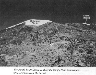
Like the Marangu Route, the Barafu Route up to the summit is essen-
dally a continuation of a lower route--the Mweka Route--through the
forest, and thus it is often referred to as the Mweka Route. The Barafu
Route starts at Barafu Huts (4,600 meters), which sit atop a prominent
ridge on the eastern side of the Southeast Valley. The Southeast Valley
lies off to the left as you look at the summit from Barafu Huts. The Barafu
Route is steep but does not entail anything harder than a stiff hike.
The route climbs the rocky prow of the rib above
the hut before winding its way up a very steep gravel trail to the rim.
The trail follows the far right side of the Rebmann Glacier; off to the
far right is the Ratzel Glacier, which has melted away so considerably
in the last ten years that it's hard to tell it's a glacier.
It takes about 5 to 6 hours to get to Stella Point
(5,795 meters), on the rim of the crater, then another hour or so to reach
Uhuru Peak (5,895 meters/19,341 feet).
Map of routes